
Part 2 of 2
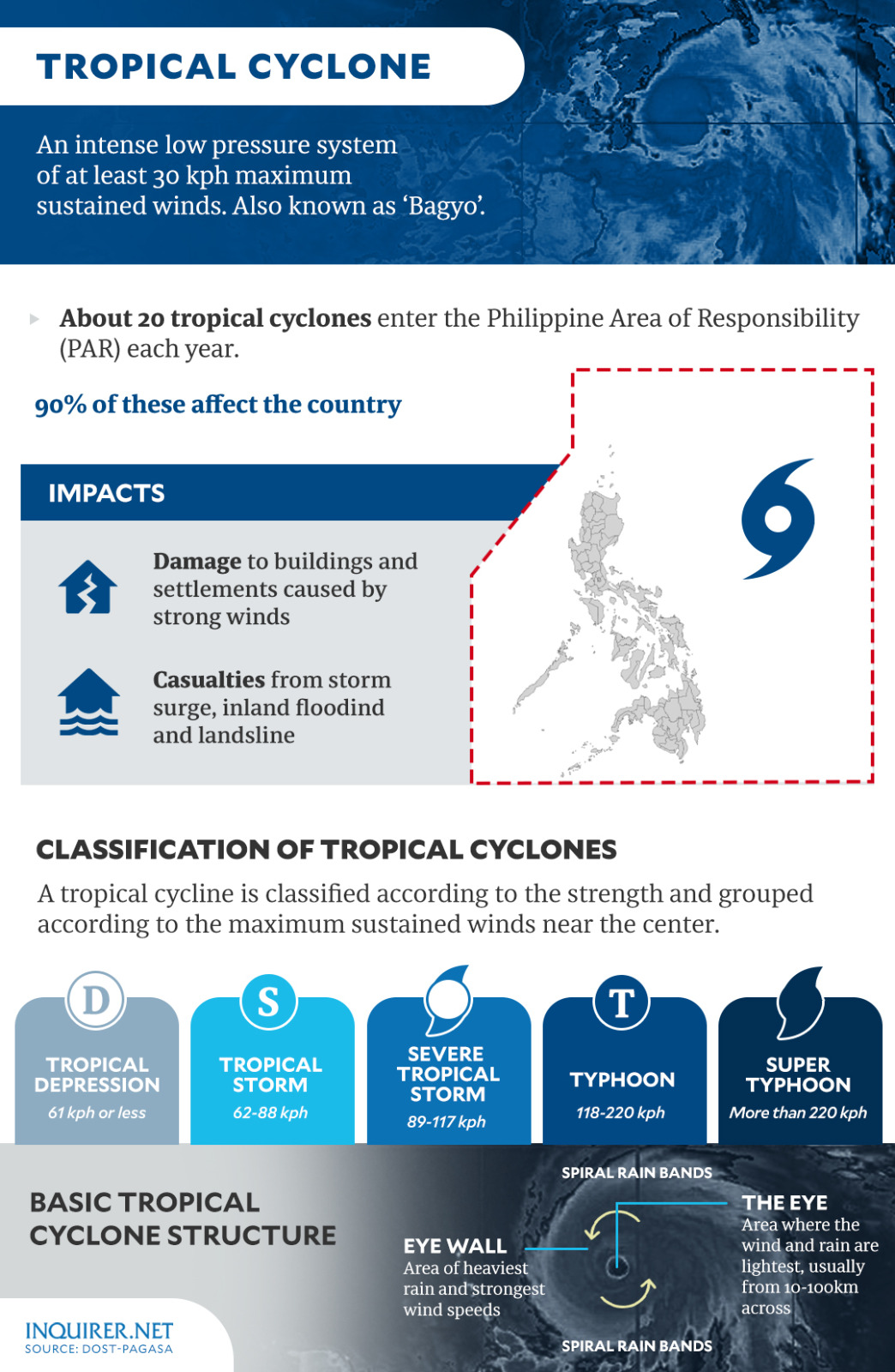
Tropical Depression Kristine was spotted 870 kilometers east of Eastern Visayas as of 10 a.m., October 21, carrying maximum sustained winds of 55 kilometers per hour (kph) and gustiness of up to 70 kph while moving west southwestward at 30 kph.
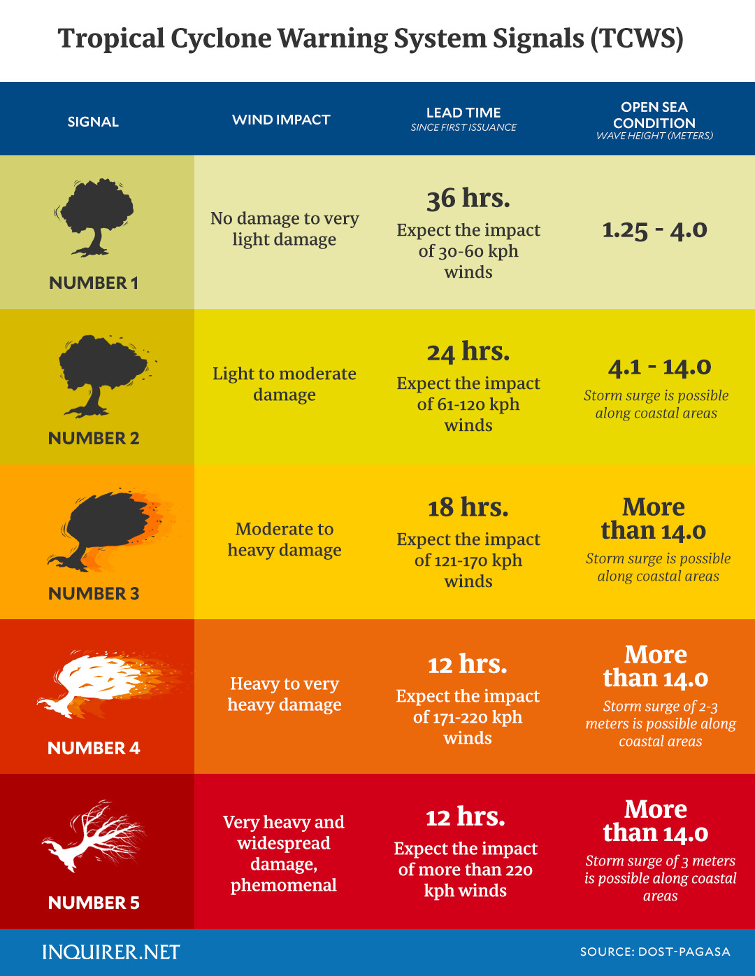
Despite being relatively far from the country currently, Pagasa raised Tropical Cyclone Wind Signal No. 1 over 15 areas nationwide.
Kristine is the 11th storm to hit the Philippines this year.
LIVE UPDATES: Tropical Storm Kristine
Tropical Storm “Kristine” continues to move west-northwestward over the sea east of Quezon, maintaining its strength. The storm is expected to intensify before making landfall and may affect several areas with heavy rainfall, strong winds, and coastal inundation.
- Today, October 23: “Kristine” approaches Isabela or northern Aurora, bringing heavy rain and strong winds to MIMAROPA, Visayas, and Mindanao.
- Tomorrow, October 24: Landfall expected over Isabela or northern Aurora early morning, crossing Northern Luzon and exiting by the afternoon.
- Friday, October 25: Storm exits PAR, possibly re-intensifying over the West Philippine Sea.
Related Posts

At 2 A.M., I Called My Parents in Tears and Begged, “Please Come Get Me and My 6-Year-Old Daughter. We Can’t Stay Here Another Night.” Mom Called Me Dramatic. Dad Told Me to Stop Blaming My Husband. Then I Discovered Why They Refused to Help: My Husband Had Been Secretly Paying Them $10,000 Every Month to Keep Them on His Side. I Hung Up, Took My Little Girl, and Disappeared Before Sunrise. By Morning, My Husband Was Calling in a Panic, Shouting, “What Have You Done?!” He’d Finally Discovered the One Secret About His Business Empire That I’d Kept From Him All Along
Part 2 of 3 He simply helped. Within an hour, appropriate professional assistance had been contacted, and arrangements were made for Caroline and Sophie to leave safely. Caroline...

Just 90 Minutes Before My Wedding, My Son’s Nanny Walked Into My Room Holding My 11-Month-Old Baby and Whispered, “Please, Don’t Go Downstairs. You Need to Hear This First.” Then She Played a Recording of My Bride’s Secret Phone Call About My Fortune—and the Son I Had Always Believed Was Mine. I Listened in Silence as Her True Plans Unfolded. With 200 Guests Waiting Downstairs, I Made One Decision My Bride Never Saw Coming: I Canceled Our Wedding Before She Could Walk Down the Aisle
Part 2 of 3 “Why is your attorney here?” Holden politely asked the stylist to leave them alone. When the door closed, he faced Tessa. “I heard the...

My 8-Year-Old Daughter Was Almost in Tears When the Restaurant Manager Pointed at My Muddy Boots and Said, “We Don’t Serve People Like You in This Section.” She Called Security, Gave Us Two Minutes to Leave, and Smirked as the Other Diners Watched. I Quietly Sent One Text Instead of Arguing. What She Didn’t Know Was That the Person Receiving My Message Could Change Everything About Her Future at That Restaurant
Part 2 of 3 Naomi’s message contained four words. We’re in the lobby. I stood. Paige seemed relieved. Then I said: “Two minutes should be plenty.” I turned...

My 5-Year-Old Daughter Called Me at Work Crying, “Mommy, Dad’s Girlfriend Hurt Me With a Hockey Stick.” I Didn’t Confront Anyone—I Called for Help and Saved Every Message. At the Hospital, They Found Marks on Her Arm and Leg. But What Surfaced Just Before the Custody Hearing Revealed That Her Father Had Known Far More Than He Had Ever Admitted
Part 2 of 3 Before going to sleep, she asked three times whether I had locked the front door. Then she whispered something that hurt even more. “Is...

At Christmas, My Mother Humiliated My 8-Month-Old Daughter in Front of the Entire Family and Blamed Me for Her Premature Birth. After 34 Years of Enduring Her Cruel Remarks, I Quietly Gathered All Seven of My Baby’s Presents and Said, “This Is Her Last Christmas Here.” She Called Me 11 Times Demanding an Apology, Certain I Would Come Crawling Back. But on New Year’s Eve, One Phone Call Revealed Something She Never Expected—and Suddenly, She Was the One Begging…
Part 2 of 3 She turned toward him. “For what? For worrying about my own granddaughter?” Grant approached with Maisie. “We’re going home,” he said quietly. Bethany stepped...